Building land register
Vacant lots and underused areas
The undeveloped plots and underused or slightly developed plots are listed below for the local districts. The list has been compiled on the basis of appearance, as the situation is on the ground and recognizable to everyone.

The following should be noted:
- It is only assumed that building is possible in principle.
- No claims under planning or building regulations can be derived from the illustrations.
- The information on planning law provided for the gaps between buildings is for information purposes only. They do not reflect the complete planning and building law.
- For data protection reasons, private owners cannot be named. They are referred to as "private". Only municipal property is listed as "city".
- It is not known whether the respective owners have an interest in building and/or utilizing the property.
- The suitability for development can only ever be clarified by means of a preliminary building inquiry or a building application.
- Any indications of contaminated sites are not noted. The absence of contaminated sites must be clarified with the Environmental Agency.
- All information is provided without guarantee of accuracy and/or completeness.
The last review of the building gaps was carried out in 2023.
Gaps between buildings in Amoeneburg

Gaps between buildings in Auringen

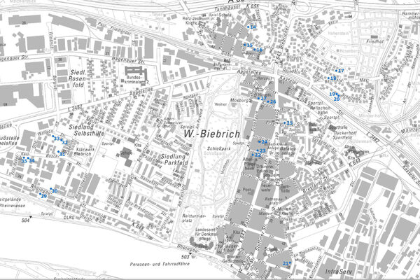
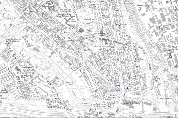
Gaps between buildings in Biebrich
Gaps between buildings in Bierstadt

Gaps between buildings in Breckenheim

Gaps between buildings in Delkenheim

Gaps between buildings in Dotzheim

Gaps between buildings in Erbenheim

Gaps between buildings in Frauenstein

Gaps between buildings in Heßloch

Gaps between buildings in Igstadt

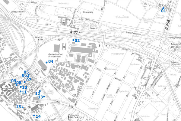
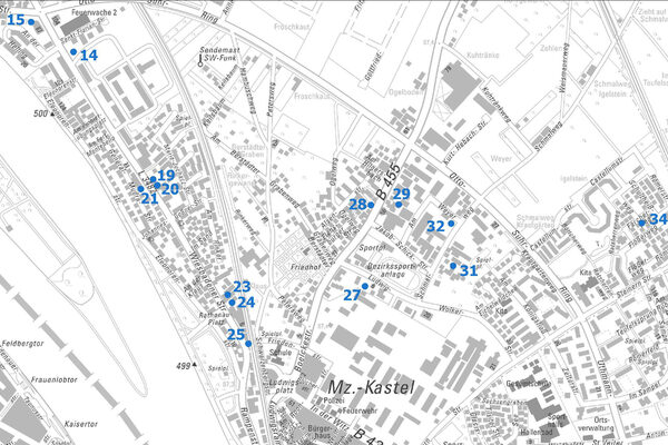
Gaps between buildings in Kastel
Gaps between buildings in Klarenthal

Gaps between buildings in Kloppenheim

Gaps between buildings in Kostheim

Gaps between buildings in Medenbach

Gaps between buildings in Mitte

Gaps between buildings in Naurod

Gaps between buildings in Nordenstadt

Gaps between buildings in the north-east

Gaps between buildings in Rambach

Gaps between buildings in Rheingauviertel/Hollerborn

Gaps between buildings in Schierstein

Gaps between buildings in Sonnenberg

Gaps between buildings in the southeast

Urban planning office
Address
Gustav-Stresemann-Ring 15
65189 Wiesbaden
65189 Wiesbaden
Postal address
P.O. Box 3920
65029 Wiesbaden
65029 Wiesbaden
Arrival
Notes on public transport
Bus stop Statistisches Bundesamt; bus lines 16, 27, 28, 37, 45, X26, 262
Telephone
Opening hours
Please make an appointment.
Information on accessibility
- Barrier-free access is available
- The WC is barrier-free