Auringen
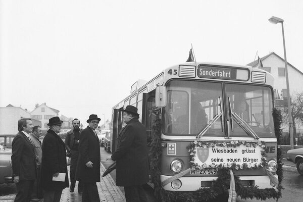
Auringen was first mentioned in writing in 1252. However, burial mounds from the Bronze Age bear witness to a settlement in earlier times. After the end of the Second World War, numerous displaced persons found shelter in the village, which was incorporated into Wiesbaden in 1977. Today, around 3300 people live in Auringen.
The former street village of Auringen lies on a ridge running from north-west to south-east between the Aubach in the east and the Zwergbach ("Schnoogebach") coming from Naurod in the west. From the confluence of the Aubach, Zwergbach and Alsbach near the Auringer Mühle mill, the watercourse is called the Wickerbach. The village lies on a stretch of the old trade route "Mainzer Straße", which led from Mainz via Limburg to Siegen and via Idstein, Usingen and Weilburg to Wetzlar.
Auringen was first mentioned in writing in 1252. In the Middle Ages, the place name was consistently "Urungen", in the 16th century "Uringen"; there was also the form "Uringheim". Both forms of the name were fashionable at the time of the Alemannic-Franconian land conquest in the 5th-6th century and mean "settlement on the Aubach". However, there is also evidence of older settlements in the surrounding area: in the forest to the left of the road from Auringen to Heßloch there is a burial mound from the Bronze Age and a Roman estate in the southern tip of the district towards Medenbach.
Auringen belonged to the Counts of Nassau. In 1355, when the Nassau-Walram land was divided, the village, which was part of the Sonnenberg office, fell to the Nassau-Sonnenberg line, which was founded at that time. When this line became extinct after the death of Count Ruprecht von Nassau in 1391, Nassau-Idstein and Nassau-Weilburg had to share the office with Count Ruprecht's widow Anna and her second husband, a Count of Katzenelnbogen. After Anna's death in 1404, it belonged jointly to both Nassau-Weilburg lines until 1605. Both rulers divided the village and the serfs, so that the part of the village to the west of the village thoroughfare (formerly Langgasse, today "Alt-Auringen") fell to Nassau-Weilburg and the eastern part to Nassau-Idstein.
Auringen lay on the eastern border of the Nassau dominion, so that the boundary between Auringen and Medenbach was also the border to the dominion of Eppstein ("Eppsteiner Ländchen", Ländchen), which Hesse-Darmstadt acquired in 1492. Kurmainz bordered to the north-east with the district of Bremthal. At the old border triangle stood a Dreimärker, the so-called "Dreiherrntisch", whose location today is approx. 500 m further south. For more than two centuries, there were ongoing disputes between Nassau and Hesse-Darmstadt about the exact boundaries of the territories and the hunting district, especially as Hesse had once held hunting rights there. The relocation of the Hessian customs post to another section of the Mainzer Straße created a triangle of around two acres in size, which was disputed for more than two hundred years and was only added to the Medenbach district after a precise survey in 1810. Auringen was compensated elsewhere. The oldest buildings date back to the reconstruction of the village after the Thirty Years' War. They were built as enclosed four-sided and three-sided farmsteads on large, elongated, rectangular plots of land, the narrow ends of which abut the thoroughfare (the "gemeine Weg", later "Langgasse", today the southern part of the street "Alt-Auringen").
Until around 1800, settlement remained limited to Untere and Obere Borngasse (the "Kirchenhügel" and the lower part of the street "Am Rebenhang"), later expanding to Bremthaler Weg ("Schloßgasse") and Nauroder Weg ("Kaiserstraße", today the northern part of the street "Alt-Auringen"). The houses on Medenbacher Weg ("August-Ruf-Straße") and on one side of the road to Guldenmühle near Niedernhausen ("Guldenweg") were only built after 1900. The two Borngassen led to Lindenborn, where the municipal lime tree stood, which was renewed in 1871 and replaced by a new tree in 2006. The property register of 1686 lists 17 farmsteads and 7 deserted farmsteads. In 1747, Auringen had 34 houses, in 1809 there were 43 houses, then 64 in 1855, 91 in 1914 and a total of 106 houses in 1939.
After the Second World War, the town took in a large number of displaced persons (30.5% of the resident population in 1950), many of whom came from what is now the Czech Sudetenland, including a particularly large group from Christdorf in the Eastern Sudetenland. From 1950, the "Rote-Berg-Siedlung" housing estate was built, followed by the "Tannenring" housing estate in 1970 and the "Auf den Erlen" development area created by private initiative in 1974.
The Auringer mill ("Schmidts Mühle"), which served as a ban mill for Kloppenheim and Auringen, has been documented since 1360. In 1704, Johann Nikolaus Reitz built the Reitzenmühle ("second mill", today Esaias). Around 1710, the Schultheiß Johann Nikolaus Ruf had the Donnermühle built on the Bleichwiese near Lindenborn (in the "Loch"). Its name indicates that it only had sufficient water for grinding when a thunderstorm had filled the mill pond. It was the only mill to have the right to retain water. As it took water away from the other two mills, the Reitzen miller Esaias bought the mill building at the beginning of the 19th century and initially had it rebuilt next to the Reitzen mill. After a fire, the single-storey building was moved to Schloßgasse (house no. 4).
In the Middle Ages, foreign monasteries and convents owned considerable land in the district. The Altmünster monastery in Mainz had owned estates here since the 13th century, a farmstead with 12 acres of land, which was leased for one malt of grain per year around 1400. The monastery of St. Jakob in Mainz also had income here from the middle of the 13th century. In 1360, the Mainz citizen Hermann Duchscherer pledged a farm and 33 acres of land to St. Stephen's Abbey in Mainz. In 1360, St. Martin's Abbey in Idstein also received an annual rent of 14 malters of grain to endow its St. Catherine's altar. The associated estates belonged to the Auringer Hof of the altar, the "Katharinenhof", whose estates were later alienated, re-established in 1442 and divided into two estates. In 1589, the estates comprised a total of 80 acres of land, plus a farmstead with three dwellings (one on "Borngasse") and the parish bakery.
In the Middle Ages, Auringen belonged to the court of Kloppenheim, to which it had to provide at least one alderman. The court, which was appointed by Count Ruprecht von Nassau-Sonnenberg (around 1340-1390), met in Kloppenheim at the church near the churchyard under the lime tree. Even after the division of the two Nassau-Walram lines (around 1425), the court remained in place for both villages, but it was now presided over by two Schultheißen: one from Nassau-Wiesbaden and one from Nassau-Weilburg. Auringen only had its own mayor from the beginning of the 16th century. Until then, both communities jointly paid certain taxes in kind to the sovereign and provided 17 days of carting services on the fields of the Wiesbaden castle estate every year.
Before Auringen was given its own church in 1716, the village belonged to Kloppenheim, whose church was donated by its patron, the Bleidenstadt monastery, and was dedicated to the patron saint St. Ferrutius. It is attested as early as the middle of the 13th century. As patron saint, Bleidenstadt Monastery collected the Auring fruit tithes. The Kloppenheim parish priest received four maltons of grain from Auringen and the so-called small tithe, which consisted of a cart of cabbage, 20 sheaves of flax, 2-3 lambs, 4-5 piglets, 32 cockerels and 150 Easter eggs.
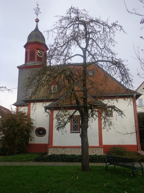
Around 1549, the Reformation was introduced in Kloppenheim and church services were held according to the Lutheran rite. When Auringen built its own church in 1716, it became a branch of the newly established parish of Naurod in the same year. The church tower was added in 1787. The organ builder Raßmann from Möttau near Weilburg created the current organ based on a plan by the organ builder Voigt from Igstadt, which was inaugurated on May 30, 1889 and replaced the older instrument from 1720. The pulpit comes from the church in Erbenheim. The area around the church was a cemetery until 1864, when a new cemetery was established in the field district "Am Säckelacker". The many new Catholic residents who settled here from 1947 onwards initially went to the church in Bremthal until they built their own church on Roter Berg, which was consecrated in 1963. In the mid-1990s, it temporarily served as accommodation for refugees from the Balkan war. A new Catholic parish center was built in the "auf dem Erlen" district at the time.
The schoolchildren of Auringen attended the parish school in Kloppenheim, which had existed since 1578. It was not until 1701 that Auringen was given its own school. A room above the parish oven on Langgasse, which was also the teacher's residence, was used for this purpose. In 1726, the parish built a new school, which was replaced by a larger building in 1824. A new school was built again in 1936 and a storey was added in 1956. When a middle school was established in Naurod in 1963, the Auring school was used as the seat of the municipal administration, which had previously been housed in a small building next to the church.
In the past, the fields were cultivated using the three-field system, as was common in the area. The names of the fields were: Straßenfeld (on Mainzer Straße), Geisenmadenfeld, Heßlocherbergfeld, Nauroderbergfeld, Mayerwegfeld (later Bremthalerwegfeld) and the field on Kloppenheimer Weg. The parcels of land that had become too small as a result of the real division were brought back to sizes that were easier to work by machine as a result of the land consolidation carried out in 1960.
When the Wiesbadener Höhenwaldungen were divided up in 1822, Auringen was awarded an area of 241 acres 67 Ruthen 7 Schuh, consisting of forest and meadows. The Auringer Höhenwald borders the Niedernhausener and Königshofener Wald and the Theisgrund to the north, the Nauroder Wald and the Kellersgrund to the east and south, and the Kloppenheimer Wald to the west.
The south-west facing slope near the village ("Wingert", "Wingertsberg" and "Am Rebstock", today "Am Weinberg" and "Am Rebenhang") was used for viticulture until around 1800. The vines were then replaced by fruit trees. After the construction of the Wiesbaden - Niedernhausen railroad line by the Hessische Ludwigs-Eisenbahn AG, popularly known as the Ländchesbahn and jokingly referred to as the "Latwergeexpress", Auringen was connected to the railroad line on July 1, 1879 and was given the station Auringen-Medenbach. After almost one hundred years, the Bundesbahn sold the line due to its unprofitability and had the station building demolished in 1972. Julius Rieser built a restaurant near the station in 1901, which was given the name "Hinkelhaus" in 1903 because of the chicken farm that was also set up there.
The municipal coat of arms, which was granted in 1952, contains the municipal lime tree and the expressive image of the rising sun (aurora). The lime tree had been used in the municipal seal since 1894; the sun was already included in the court seal of 1700, together with a sleeping man and the letters ADE (aurora dormientem excitat, the dawn awakens the sleeping man). On January 1, 1977, Auringen was incorporated as a district into the state capital of Wiesbaden.
Literature
- Schüler, Theodor
The village of Auringen and its relations to the neighboring communities. In: Alt-Nassau 1912 (No. 1 - 3)
- Beyer, Johannes B.
Chronicle of the municipality of Auringen, (op. cit.) 1977.
- Dauber, Helmut
The Dreiherrnstein near Auringen. In: Rad und Sparren 14, 1986 (pp. 26 - 33)
- Renkhoff, Otto und Dauber, Helmut
Auringen. In: Nassauische Annalen 108, Verein für Nassauische Altertumskunde und Geschichtsforschung (ed.), Wiesbaden 1997. (pp. 299 - 317)
- Dauber, Helmut
Chronicle of Auringen 1252-2002. Wiesbaden-Erbenheim 2001.

