Adolfshöhe
The inn "Adolph's Höhe" was opened in 1856 and named after Duke Adolph zu Nassau. It was located on the Biebricher Chaussee, which had connected Wiesbaden and Biebrich for centuries. After the residence was moved to Biebrich in 1744, the country lane was extended between 1749 and 1752 to become the "Neue Mosbacher Straße" and in 1808 to become the Chaussee (today Biebricher Allee). With the end of the Duchy of Nassau in 1866, the district boundary on the Adolfshöhe became the city boundary between Wiesbaden and Biebrich. The first villas were built on the hill around 1870. From 1889, a transport link was established with a steam streetcar and electrified in 1900.
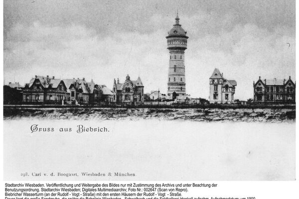
Subsequently, the villa area on the Adolfshöhe was expanded further and still presents itself today as a cohesive ensemble. It was built in 1905/06 in the country house style, based on the so-called Darmstadt style, as represented by the architects Friedrich Pützer and Heinrich Metzendorf, for example. The 42-metre-high water tower (1897), the Landesdenkmal railroad station (1907), the Nassauische Landesdenkmal and the Henkell & Co. sparkling wine cellar building (1909) were prominent buildings on the Adolfshöhe. From the end of 1929, the Gemeinnützige Aktiengesellschaft für Angestelltenheimstätten (Gagfah) built smaller homes on a plot of land. From the mid-1950s, a large area to the east of the street between the water tower and the so-called Zweite Ring was developed with detached houses and apartment buildings. A new district was created with the Heilig-Geist-Kirche church, built according to plans by architect Herbert Rimpl, at its center.
Literature
Schmidt-von Rhein, Andreas: Adolfshöhe and Biebricher Allee. Link between Wiesbaden and Biebrich. In: Schmidt-von Rhein, From Biebrich to Wiesbaden [pp. 71-101].