Heavy rain hazard maps and risk warning maps for Wiesbaden
What do heavy rain hazard maps and risk warning maps show?
Heavy rain information maps are particularly helpful for larger built-up areas in medium-sized and large municipalities, but also for new planning areas in the city. They show the flow paths of the water and depressions in which water can collect. This makes it possible to estimate the extent and possible water depths that can occur during defined amounts of heavy rainfall. Smaller obstacles such as kerbs, garden walls, driveways, ditches or culverts are also taken into account, which allows much more accurate statements to be made than with the flow path maps.
The risk information maps are based directly on the heavy rain hazard maps and relate possible water levels during heavy rainfall to the edges of buildings. Different colored markings on the buildings indicate whether there is a risk that requires an on-site inspection.
The heavy rain hazard maps are based on a large amount of data that enables high-resolution hydraulic simulations. In addition to the topography of the terrain and the existing structural features (such as bridges, walls, ditches and culverts), defined heavy rainfall volumes are also included.
Heavy rain hazard maps and risk warning maps for Wiesbaden
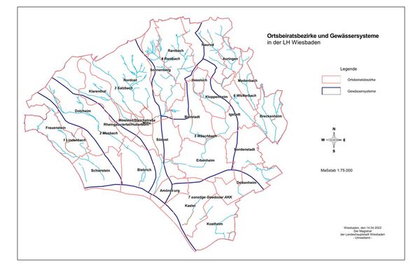
A total of seven water systems are spread across the area of the state capital of Wiesbaden. They are named after the Lindenbach, Mosbach, Salzbach, Rambach, Wäschbach and Wickerbach as well as smaller watercourses in the Amöneburg, Kastel and Kostheim areas, and they include a large number of smaller streams. The heavy rain hazard maps and the risk information maps derived from them enable an initial risk assessment and show where control or retention measures may be necessary and useful in order to reduce consequential damage.
Hazard maps, information maps and flow path maps in the geoportal
The heavy rain hazard map, the risk information maps (each for intensive and exceptional heavy rainfall) and the flow path maps can be viewed via the geoportal of the city of Wiesbaden.
Risk information map as PDF map sections
The individual map sections can also be called up or downloaded as print-friendly PDF files below. Please note that the files are many megabytes in size, as they contain high-resolution maps. It is therefore essential that you click or open the files via a WLAN connection, preferably on your desktop PC. The short link to find the files is wiesbaden.de/starkregen.
The location of the individual catchment areas can be found on the overview map (enlarges when clicked).
- 1-2 Linden-/Mosbach risk information cardPDF-File48,43 MB
- 3 Salzbach risk information cardPDF-File52,79 MB
- 4 Rambach risk information cardPDF-File25,20 MB
- 5 Wäschbach risk information cardPDF-File33,92 MB
- 6 Wickerbach risk information cardPDF-File42,03 MB
- 7 AKK Risk information cardPDF-File45,09 MB
- Explanations of heavy rain hazard and risk information mapsPDF-File100,92 kB
Contact us
Environmental Agency
Address
65189 Wiesbaden
Postal address
65029 Wiesbaden
Arrival
Notes on public transport
Bus stop Statistisches Bundesamt; bus lines 16, 22, 27, 28, 37, 45, X26, x72, 262
Telephone
Information on accessibility
- Barrier-free access is available
- The WC is barrier-free


