History Rheingauviertel - Between Ringkirche and Europaviertel
Wiesbaden's expansion to the west: the Rheingau district developed after the construction of the Ringkirche church between 1892 and 1894. The streets are named after places and vineyards in the nearby Rheingau.
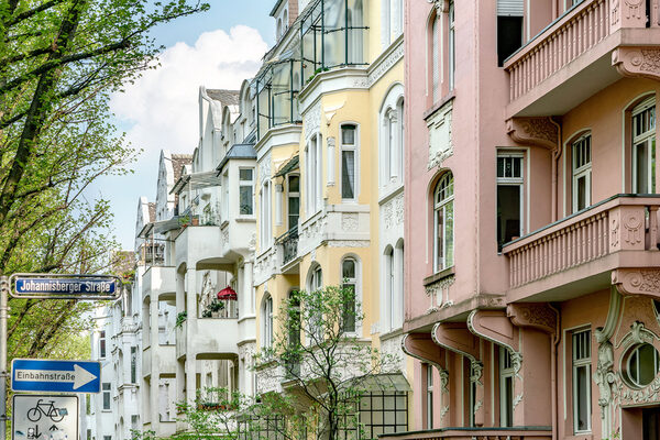
A quarter is created
Rauenthaler, Rheingauer, Erbacher, Eltviller, Kiedricher, Marcobrunner and Winkeler Strasse were built first, followed by Hallgarter and Johannisberger Strasse in 1906. Prior to this, there were only a few buildings along Dotzheimer Strasse and Schiersteiner Strasse in the Rheingauviertel and Hollerborn areas, including the Paulinenstift, which was opened in 1896.
From the parade ground to Lindsey Air Station
From 1868, a parade ground was laid out on Schiersteiner Straße. The infantry barracks were built here between 1896 and 1898 and extended between 1908 and 1911. In 1945, the American armed forces took over the site and named it after Captain Darrel R. Lindsey. Lindsey Air Station was the headquarters of the US Air Force in Europe until 1973. After the site was returned in 1993, the European Quarter was built here, providing new living space and new locations for municipal authorities and the adult education center.
The surrounding areas
The actual Rheingau district, with streets named after places in the Rheingau region, was built between 1902 and 1908. The first section of road in the Rad district was also developed during this time. The West goods station and numerous industrial companies settled here. Haulage companies, coal merchants and scrap metal recyclers characterized the area around Dotzheimer Strasse for many years. In 1930, the Rheingau district began to expand westwards between Loreleiring and Aßmannshäuser Strasse. Over the course of the 20th century, the gaps between buildings filled up and the area continued to develop.
Hollerborn and Wellritztal after the Second World War
Until after the Second World War, Hollerborn and Wellritztal were mainly characterized by market gardens, bleaching meadows and allotments. In the 1930s, construction began on the Kleinfeldchen sports center and outdoor pool, which was completed in 1951 and supplemented by an indoor pool in the 1970s. The first housing estates were built here in the 1950s. From 1958 to 1963, the August-Hermann-Francke School was built on Hollerbornstraße, and the site is now home to the Ursula-Wölfel Primary School - a school building constructed entirely of wood.
Post-war buildings and historical relics
After the Second World War, new buildings such as the Federal Criminal Police Office, which opened in 1953, and smaller projects such as the Brockhaus publishing house on Leberberg contributed to further urban development. The Platte hunting lodge, built between 1823 and 1826 and destroyed in 1945, was historically restored. The ruins are a testimony to the town's history and are now a popular venue for events. It is located on the edge of the city forest on the historic "Platea", a road that has always connected the Rhine with Limburg.
Important construction projects in the 1960s and 70s
In September 1966, the main fire station of the professional fire department was opened on Kurt-Schumacher-Ring. This was followed in 1969 by the construction of the new Dilthey School on Georg-August-Straße, whose tradition dates back to 1543. A striking building in this area is the RheinMain University of Applied Sciences, founded in 1971 on Kurt-Schumacher-Ring and Klarenthaler Straße.
Historical highlight
The Ringkirche impresses with its circular arrangement around the central altar and the eastern towers, which form a striking end to the Rheinstraße.