Thermal springs
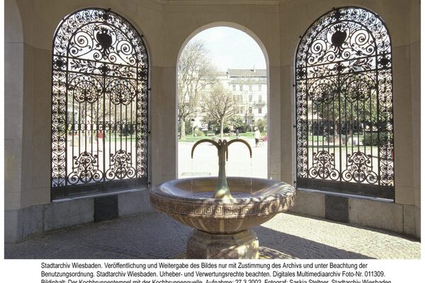
With thermal water ranging from 65 °C to more than 70 °C, Wiesbaden is the "hottest" place in Hesse and only one of a few others with a similar water temperature in Germany and its neighboring countries. The thermal water is mainly contained in the 47 m to 125 m deep Kochbrunnen, Salmquelle, Adlerquelle and Schützenhofquelle wells. The somewhat remote Faulbrunnen also contains thermal water, but is not warm enough to be called a "thermal spring". There are also around 20 shallow thermal springs, but these are generally located on private land and are not accessible. Of these, only the Bäckerbrunnen, which used to be fed by several shallow springs but has been supplied with mixed thermal water since the 1930s, is accessible. In August 2011, the Drei-Lilien spring, which had been neglected for a long time, was reopened to the public following its restoration.
The main springs are located on a line running north-northeast. However, there is no continuous fissure zone as previously assumed by geologists. As a rule, each of these springs is accompanied by weaker secondary springs (satellites), all of which are shallow and unused. In the south-eastern undercurrent of the large thermal springs, which are also known as primary springs, are the aforementioned shallow thermal springs, whose water is diluted by "normal" groundwater.
A total of 26 thermal springs are known in Wiesbaden. Their total discharge is around 23 l/sec (2 million liters/day). Their solution content, mainly common salt, amounts to 14 to 17 tons/day. Drillings for various construction projects in the spring district, but also far away in the Rambach valley at the Blumenwiese, have shown that in addition to the fissures where the large thermal springs come to light, there must be other fissure zones containing thermal water that have not yet been investigated in detail.
Various researchers have expressed different opinions about the origin of the thermal water containing common salt. One opinion was that the saline water came from the Hessian-Thuringian salt deposits around Werra and Fulda and from there it should have traveled in a north-easterly direction under the Vogelsberg to the edge of the Taunus.
Plate tectonics, which has been recognized since the 1970s, provides a key to a better understanding. Wiesbaden lies at the northern end of the Upper Rhine Graben, which is a continental rift zone. Its edges still diverge by millimeters per year. As a result, new deep cracks are constantly forming as migration routes for the thermal water, which brings its temperature from the geothermal depths. While the temperature outside the Upper Rhine Graben increases by an average of 3 °C for every 100 m of depth, the geothermal temperature gradient in the graben is 4-6 °C/100 m. To reach 70 °C, it requires a depth of at least 2,000 m, as the thermal water releases heat into the environment as it rises. However, outside of rift zones, there are generally no open fissures at this depth that can absorb and transfer the large quantities of water that reach the surface in Wiesbaden. Only in a rift zone do new open fissures constantly form as the plates move apart, even at the required depth. The thermal water can therefore only flow in from the south with the rift zone, but encounters resistance when it reaches the Taunus and is forced to rise to the surface.
Thermal water also rises to the earth's surface in other places as the open fissures at the edge of the Taunus fade (e.g. Assmannshausen, Kiedrich, Bad Soden am Taunus, Bad Homburg, Bad Nauheim), but the temperature drops rapidly to the west and east of Wiesbaden. It is therefore assumed that the Wiesbaden thermal water deposits represent the center of the still expanding rift zone. The inflow of thermal water from the south also explains the enrichment with salts. For many years, they were mined at depths of 500-800 m in southern Baden and Alsace and at depths of 1,600-1,800 m in the Bruchsal-Worms area. The water, which is mainly enriched with common salt (sodium chloride), is specifically heavier than the overlying fresh water, which is supplemented by precipitation, and sinks into the depths as far as is possible in open fissures.
However, there are now also other interpretations of the occurrence of saline hot water that do not require salt deposits or the rift zone of the Upper Rhine Graben. In deep boreholes up to 9 km in granites or gneisses, it was found that at this depth the rocks are not as dense as was always assumed and therefore hot hydrothermal solutions of 150 °C and more can circulate. These are extremely salty, the salts result from the transformation of minerals in contact with the hot water. The table salt content is not the highest of the spas on the edge of the Taunus in Wiesbaden. Here it is Bad Soden, Bad Homburg and above all Bad Nauheim that have significantly higher salt contents in their thermal waters and also operated prehistoric salt extraction.
Literature
Czysz, Walter: Vom Römerbad zur Weltkurstadt, Geschichte der Wiesbadener heißen Quellen und Bäder, Wiesbaden 2000 (Schriften des Stadtarchivs Wiesbaden 7).
Michels, Franz: The Wiesbaden mineral springs. In: Jahrbuch Verein f. Naturkunde 98/1966 [pp. 17-54].
Stengel-Rutkowski, Witigo: Hydrogeological guide to the saline thermal springs of Wiesbaden. Ed.: Nassauischer Verein für Naturkunde, Wiesbaden 2009.
